Cleggan Point lighthouse

Cleggan Point (photograph Richard Sharpe)
I have been neglecting concrete box lighthouses for a long time now. I know a lot of people - my long suffering wife included - do not rate them as 'proper' lighthouses, probably because they aren't actual houses but they have helped enormously in providing safe passage for those at sea and, like Inshirrer, Wyon Point, Inishnee and Ravedy Island, are often situated in stunning locations. It seems most, if not all, of them are located between Galway Bay and the Foyle or from Loop Head to Malin Head, as they might say on the weather forecast.
But yes, they completely lack architectural merit.
But yes, they completely lack architectural merit.

Judging by the photograph above, by Richard Sharpe, the light at Cleggan Point, or Cleggan Head, looks to be of a similar construction to the Fastnet, though I doubt it took seven years and 2,074 granite blocks to complete. But the courses did begin at the bottom of an incline and grew in size as the courses accumulated. And the current lighthouse did replace an earlier tower, In fact, the base of the box in the picture above looks like it might have been the bottom of the original tower. But more of that anon.

Photo from the Inisbofin ferry. Dull, grey skies are my photographic hallmark
Cleggan is a very small fishing village about 10kms north west of Clifden at the very edge of Connemara. It has an extremely sturdy and long stone pier (extended in 1908) built by our old friend Alexander Nimmo who did so much for the wesht, as well as designing the incredible lighthouse at Dunmore East. Fishing out in the imaginatively-named Cleggan Bay has been a source of income for centuries. In 1927, a sudden gale robbed the area of 25 fishermen in the Cleggan Bay disaster, as well as ten from the Inishkea Islands off the Mullet Peninsula and nine from Inishbofin.
Cleggan itself sits on the south side of the bay. On its journey to Inishbofin and Inishturk, the ferry passes by Cleggan Head at the northern entrance of the bay.

Cleggan Head (or Point) top middle, the promontory at the top of the page directly above the C of Cleggan (Mapcarta)

My own photograph in June 2021. Either the lighthouse was slanting or I was.
As far back as 1852, the Dublin Evening Mail, quoting the Earl of Mayo, said that "the Black Rock, which was 200 feet high, was an eligible place for a lighthouse; a second (was) to be placed on Blacksod Point; and a lantern light on Cleggan Point," which is the second time in this short article that Cleggan has been mentioned in the same breath as the bigshots of the Irish lighthouse world.
It is unknown whether this lantern ever shone forth from the headland, though the Earl of Mayo was renowned as being a terrible fibber. It seems as though by the end of the century, it was not shining forth, fifth or even sixth, as the Galway Express reported that "Gossip is busy in disseminating the rumour that, on the promontory of Cleggan Head, there is to be a light every night, by means of which the vessels can steer clear of the rocks with which the channel between the point and Boffin Island is strewn."

Looking across to the southern entrance of the bay (photo Richard Sharpe)
I've not been able to find out exactly when the first light on Cleggan Point or Head was established but it was after 1896 (the date of the clipping above) Most sources give the year as 1901, which would fit into it being a project of the Congested Districts Board who were doing a lot of work in places like Gortumna, Cashel and Leenane at the time. At Kilronan they provided a harbour light and money to maintain it, so I'm guessing they did the same at Cleggan.
There is a similar white concrete equipment room with a light at Lyon Point on the eastern approaches to Boffin. The two lights may have been erected in tandem, though information is scarce.

Another Richard Sharpe. There is no road out to the headland but it is walkable
Thanks to the US Hydrographic Office, we know that the light was exhibited from the top of a 10 feet tall grey, stone tower which stood 60 feet above high water. I have no pictures of this grey, stone tower unfortunately but the second picture on this page shows the base of the present concrete box to be square and grey and built of stone. Thus I suspect that either the tower was knocked down to the base to erect the white concrete box or it blew down to that level and had to be replaced. The light in 1917 was fixed with red, white and green sectors, probably acetylene based, though I could be wrong.

My own slightly straighter photo from the Boffin ferry
Thanks to Richard, we know that the three men who constructed the square concrete box were John O'Toole, his grandfather, Tom King and J. Lynch. It is taller by half than the tower it replaced, standing 15 feet (4.5m) tall and 66 feet above high water. It seems as though the three men would often travel across to the point in Tom King's curragh, which indicates they may well have been the attendants of the light as well, which would make sense. The building materials got there by curragh and then were hauled up the headland.
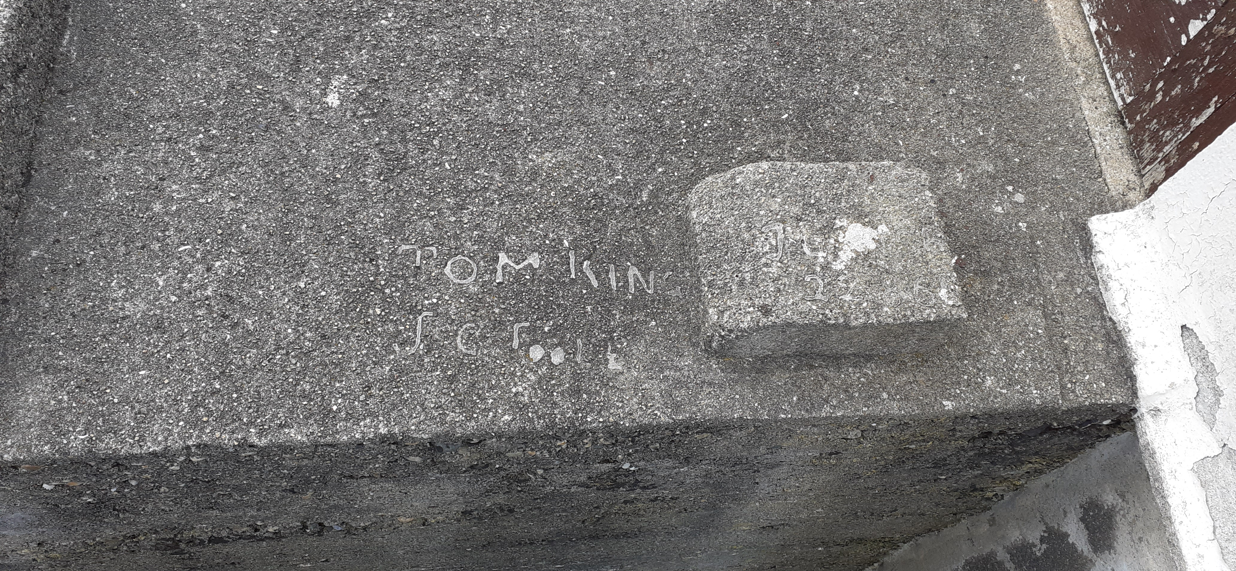
Dedicated preservers of maritime heritage, the three lads even autographed their handiwork for the benefit of future historians


Note too the solar panel in the bottom picture. The 1961 light seems to have been electric. The white light is visible for 6 nautical miles, the red and green for three nautical miles.


Comments
Post a Comment