Saturday, October 28, 2023

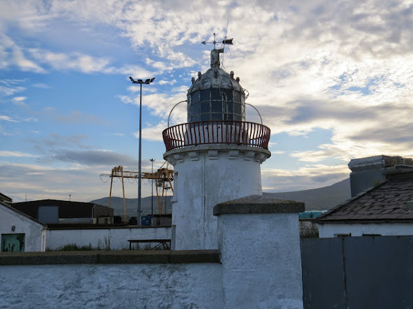
The case of the invisible lighthouse

(Lee Maginnis, lighthouse enthusiast (providing they are built of certain materials and are of a certain size)  from county Down, sea-swimmer, athlete, journalist and goatherd, writes this post on one of the Irish lighthouses that never gets a look in - Ardglass)

It all began with an advert asking for volunteers to work at Spurn Lighthouse.  I thought immediately of the Goulding family in Ireland.  Mrs. Goulding might fancy a break.  Spurn being in Yorkshire, she could send her lighthouse historian husband Peter away for his treat, while enjoying a fortnight's respite at home herself.
Peter, in turn, after the suggestion, had an idea of his own.  I should take over care of Ardglass Lighthouse as it was in need of attention.
Now Peter knows very well that I am a fan of big lighthouses that are made of granite.  I googled the lighthouse and was rewarded with a fantastic view taken from a helicopter, or more likely, a drone.  It looked white, and big, painted stone?  With the benefit of hindsight, I realise there was no sense of scale in the photo.
I had a nagging doubt in the back of my head.  I had been mackerel fishing at Ardglass a number of years ago.  How come I had never seen any lighthouse?
Maybe it was round the coast a bit from the harbour.  Ardglass being a village synonymous with the fishing industry.
Anyway, rained off at work, my chance came and I headed off with my pal Cane.  Arriving in Ardglass in the afternoon, I was a little puzzled.  Number one, there seemed to be two harbours.  Number two, I could see no sign of any lighthouse, although there were many other old buildings to keep me well occupied.

Probably the oldest clubhouse in the world.  Ardglass Golf Club claims the clubhouse was founded in 1405!!  Maybe the clubhouse was founded and the golf followed a few hundred years later?

I stopped at a local business and found a man behind his kiosk who looked like he has just stepped off a pirate ship!  Heavily bearded and with long hair, he bemoaned how Ardglass was lagging behind Newcastle as a tourist destination.  I asked him where the lighthouse was and he very obligingly pointed down the coast and said that I barely had to leave the village before I would see it on the right hand side.
He would have been more helpful if he had told me the lighthouse was visible from behind his establishment and that I didn't have to leave the village at all...  maybe he was not so keen on tourists after all.
After a quick and fruitless search up the coast, I asked another local, she more accurately pointed to the marina (apparently one harbour was a marina, I am not sure what the difference was supposed to be).  She also rather cheekily remarked that she had no idea how I missed it.
When I round it, I could easily see how I missed it.  It was not that big after all.  It was not granite either.  It was dwarfed by surrounding buildings, blocked from view by a couple of parked lorries and also partially obscured by the adjoining building, surely not a dwelling house, but maybe so as there was not enough room to swing a cat in the actual tower.  Judging from the rust, the only thing Peter had been accurate about was the fact it could do with some attention.  The glass in the lamp room had also been broken and looked like perspex had been stuck across it as a repair job.


Cane inspects the view and enjoys the smell of fish.


The lighthouse.  With terribly positioned CCTV cameras.

The light would need to be a lot more visible from sea, than it is from land!  It is perched at the end of a harbour wall.


One of Peter's friends arrives and enquires why he never appeared on the Copeland Islands in August.


Cane takes shelter from the rain, in a little tower surrounded by the sea, only to find there was no roof.


Another example of the incredible architecture on display in Ardglass.  I have no idea what it is, possibly a private dwelling!

Many thanks to Peter for a thoroughly enjoyable couple of hours in a pretty amazing maritime village.  I must apologise for having a brief suspicion that he had sent me on a wild goose chase.  Or actually, regarding granite stone lighthouses, he really did!

Saturday, October 21, 2023

Good news from the East Coast of Ireland Part 2.


It is nine years since I visited Greenore at the entrance to Carlingford Lough. There has been a lighthouse here since 1830, erected after representations from the Newry Chamber of Commerce. Not only was it an important harbour light in its day but, in conjunction with the much more famous and statuesque Haulbowline light in the centre of the lough, it also helped the wary mariner clear lurking dangers at the entrance to the lough.  


The light really came into its own with the building of the Dundalk and Greenore Railway in the 1860s. Shipping routes to Heysham and Fleetwood brought prosperity to the area and a large hotel was built to accommodate visitors. 
Unfortunately, the partition of the country saw the port go into decline as northern travellers to Britain often didn't fancy journeying to the Free State to avail of shorter shipping routes. The lighthouse was discontinued in 1986 and has sat disconsolately behind a wall and a locked gate ever since.


I commented on its dilapidated appearance in my 2014 post and, in fact, put the sorry-looking light on the second version of my lighthouse fatalities book last year. The lighthouse itself was dirty and unkept but of more serious concern was the adjoining cottage, which had windows smashed and slates missing from the roof. The writing seemed to be on the very grubby wall for Greenore lighthouse.


But then, a couple of years ago, there were rumblings that the tower and cottage were going to be given a makeover. Yeah, right.


Greenore in 1905, photos taken during a Commissioners' inspection

But, a couple of days ago came proof that, in fact, the rumours had been true and I had been my usual negative and wrong self in doubting them. Lee Maginnis, who was probably in the Marines in his younger years, managed to get these photos of the newly painted tower and newly-painted and restored cottage.


How fantastic do they look now!! I can't vouch that the same care to design and materials was given as was lavished on Broadhaven lighthouse but, hell, it would make great tourist accommodation with maybe a tree or two to mask the somewhat unattractive port hinterland.


There's an old saying around the Carlingford area - "Where there's a Lee, there's a Cane." And so, once again, Ireland's most photogenic lighthouse dog strikes the pose.

Tuesday, October 17, 2023

Good news from the East Coast of Ireland Part 1


Wicklow Pierhead lighthouse pre-Independence, with hat and feathers.

Some really good news this week from the east coast of Ireland regarding two of our lights.
First off, there's the Wicklow pierhead light which I wrote about here
Basically a storm in January 1976 lifted off the beautiful old copper dome and weather vane from the lantern room and deposited them in the harbour. It was deemed uneconomical to repair them and so a makeshift cap was made by a very decent local tradesman to allow the light to continue. Plenty of photographs on the Wicklow Maritime Facebook page!


Then, around a year ago, there were rumblings that the Port Authority were looking at returning the dome to its rightful position. Yeah, right!
But then, this weekend just gone, it all came to pass! The dome was repaired by Arklow Marine Services  and was reunited in Arklow with the lantern room. On Sunday, it was returned to the pier and was hoisted into place early on Monday morning. Looks great! Fair play to all involved.


Wednesday, October 11, 2023

Gola Island (Oileán Ghabhla) and Rinnalea Point


My thanks to my brother-in-law Aido who, combining his love for Donegal with his keen interest in islands, took in the formerly inhabited island of Gola on a recent trip up that way, and took photos of a couple of interesting beacons there. Beacons about which I can find practically nothing online, so any help would be greatly appreciated.
Gola incidentally is an island off the north-west coast of Donegal between Arranmore and Bloody Foreland.


The unusual beauty at the top of the page is roughly eight feet (2.6 meters) tall and is situated in the pier area on the eastern, mainland-facing side of the island. It appears to have maybe once held a hurricane lamp or something to guide in boats at night but now the bulb on top works on solar power. (Of course, it might also have held a statue of the Virgin Mary!)
On the south east part of the island there are two beacons which act as leading lights for the boats coming from Bunbeg. The front beacon sits on a rock on the shoreline and the rear beacon further up the headland. They seem to be made of concrete blocks painted a very aesthetically-pleasing brown / fawn combination. Actually the front light is supposed to be white with a black band, while the rear light should be black with a white band and they are 20 feet and 16 feet tall respectively, with heights above sea level of 29 feet and 43 feet. They both are occulting white lights, shining for two seconds out of three with a range of 2 nautical miles. They are 250 feet apart


E-Oceanic chart showing the leading lights (bottom right) and the Pier (top centre) though the solar powered light is not shown

Gola Island was inhabited up until the 1960s, when the closure of the island school meant that the last few remaining islanders moved to the mainland. Two of the crew of the Asgard, which landed arms for the Volunteers at Howth in 1914, were from Ghabhla and a monument to them sits on the island. It was completely uninhabited until the 1990s when some of the original inhabitants, or their children, started doing up the old family homes and using them as holiday homes. Mains electricity came to the island around 2005 and there is now a coffee shop on the island during the summer months and a portaloo too.
The island has a walking trail of roughly 3.5 kms and is noted for its natural beauty and stunning views. The Cricket - the ferry - operates during the summer months from Bunbeg.
While we're up in this incredibly beautiful part of the world, I came across an entry in the 1917 British Islands Pilot for a light at Mullaghderg:


Mullaghderg is the large headland in between Cruit Island and Donegal Airport, as per this map with the expertly drawn arrow, shows.


Naturally, being a total nerd, I was excited at the prospect of a square tower in 1917, in a place where I didn't think one had existed. However, I could find little about this 'Mullaghderg Lighthouse' online. So, as all good historians do, I put out an APB on the local Facebook site, which, in this case, was Arranmore. And it worked!
Joseph Doherty, good man himself, explained that it was a light for navigation to Kincasslagh pier and its arc of visibility was between Owey / Cruit Islands and Inishfree Island, which is the large-ish island sticking down top centre in the map above.
Not only did Joseph inform me that the light was called Rinnalea Point but he also sent me a photo of it.


To be honest, okay, its not a tower lighthouse. Its one of those white concrete boxes that they love along this coastline - Wyon Point, Inishsirrer, Bloody Foreland etc - which excites nobody except myself. Did they have white concrete boxes in 1917? No idea. Doubt it.
Two things that seem odd about the light. Firstly, it looks like they placed it in a hollow in the rocks. Great protection from the sea but can it be seen from the water? 
Secondly, what is the purpose of those two block towers by the side of it? The only thing I can think of, is that it marks out the arc between Owey / Cruit and Inisfree. Any better suggestions gratefully received!
Armed with the information that it is called Rinnalea Point, I was able to find it on Trabas. It is Admiralty Light A6206 and it flashes white for 0.3 seconds every 7.5 seconds. It is described as a 7 feet tall tower (hmmm), 62 feet above high water and a range of 9nm.


The photo on Trabas, with the mountains behind, looks like it was probably taken from the sea and, if so, confirms that it can be seen from that direction. I'd have been worried if it wasn't.

Incidentally, I have been to nearby Cruit Island but have never managed to get to Owey. It is a favourite island among cliff climbers and was once a big mover in the world of illicit distillation. A keeper from the late 1800s, one Andrew McGonagle (1855 - 1931) came from Owey and returned there after serving at Skellig Michael, the Hook, the Baily and others.  Aido however, managed to find a local fisherman to bring him over and reported that, on the island, amongst other things, is an underground lake, situated under an overground lake. Which I think is pretty cool.

Wednesday, October 4, 2023

The Tagoat cliff top lighthouse (revisited)


What I believe is the old lighthouse at the end of the old Ballygeary pier which served Rosslare Harbour before the current pier came into existence in 1906

On a recent trip to see the Maritime Exhibition in Kilmore Quay (great stuff, lads and lasses) I decided to nip over to Tagoat to see if I could find any evidence of a lost lighthouse on the cliff top. I've been banging on about this lighthouse and its brother on Ballygeary pier a couple of times (see here and here) and not had much response, save to say that, if there had been a lighthouse at Hill of Sea, it would have fallen victim to coastal erosion years ago, which is fair enough.
Suffice to say that, unsurprisingly, there was no evidence of a lighthouse at Hill of Sea. Of course, I may have been looking in the wrong location. There is some discrepancy in the O.S. maps at the period in question, which doesn't help. The 25 inch map shows it quite definitely:


So, head from the pub and graveyard on the main road towards the sea. Take the small road to the right where the main road turns left and follow it until it crosses the railway. Look north and halfway between that bridge and the next bridge, right next to the railway line, is the black dot that signifies the lighthouse. 
However, when you go into the 6 inch map, the lighthouse has disappeared.

Okay, I accept its possible that they prepared the 25 inch map and by the time the 6 inch map was ready, the new Rosslare pier light was operational.


This is a Google Street map view from the Rosehill bridge looking south to the Hill of Sea bridge. The lighthouse should be on the left hand side of the track? As you can see, there's a lot of land between the track and the cliff, yet no ruined house?
What other clues do we have?
  • The Notice to Mariners at the end of 1894 says the fixed green light is "to be exhibited from a window in a Light House situated on the Cliff one and a half miles from the light at the end of Rosslare pier."
  • There were only three houses at Hill of Sea in the 1901 Census. Two were private dwellings; the third was built on land owned by the G.W. & S. Railway.
  • It was a three-roomed house, according to the 1901 Census

I'm presuming that an Admiralty Chart between 1895 and 1906 would show the location of the lighthouse. But I'd still love to see a picture of it.