Gola Island (Oileán Ghabhla) and Rinnalea Point

My thanks to my brother-in-law Aido who, combining his love for Donegal with his keen interest in islands, took in the formerly inhabited island of Gola on a recent trip up that way, and took photos of a couple of interesting beacons there. Beacons about which I can find practically nothing online, so any help would be greatly appreciated.
Gola incidentally is an island off the north-west coast of Donegal between Arranmore and Bloody Foreland.

The unusual beauty at the top of the page is roughly eight feet (2.6 meters) tall and is situated in the pier area on the eastern, mainland-facing side of the island. It appears to have maybe once held a hurricane lamp or something to guide in boats at night but now the bulb on top works on solar power. (Of course, it might also have held a statue of the Virgin Mary!)
On the south east part of the island there are two beacons which act as leading lights for the boats coming from Bunbeg. The front beacon sits on a rock on the shoreline and the rear beacon further up the headland. They seem to be made of concrete blocks painted a very aesthetically-pleasing brown / fawn combination. Actually the front light is supposed to be white with a black band, while the rear light should be black with a white band and they are 20 feet and 16 feet tall respectively, with heights above sea level of 29 feet and 43 feet. They both are occulting white lights, shining for two seconds out of three with a range of 2 nautical miles. They are 250 feet apart


E-Oceanic chart showing the leading lights (bottom right) and the Pier (top centre) though the solar powered light is not shown
Gola Island was inhabited up until the 1960s, when the closure of the island school meant that the last few remaining islanders moved to the mainland. Two of the crew of the Asgard, which landed arms for the Volunteers at Howth in 1914, were from Ghabhla and a monument to them sits on the island. It was completely uninhabited until the 1990s when some of the original inhabitants, or their children, started doing up the old family homes and using them as holiday homes. Mains electricity came to the island around 2005 and there is now a coffee shop on the island during the summer months and a portaloo too.
The island has a walking trail of roughly 3.5 kms and is noted for its natural beauty and stunning views. The Cricket - the ferry - operates during the summer months from Bunbeg.
While we're up in this incredibly beautiful part of the world, I came across an entry in the 1917 British Islands Pilot for a light at Mullaghderg:
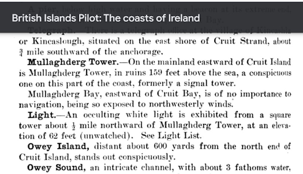
Mullaghderg is the large headland in between Cruit Island and Donegal Airport, as per this map with the expertly drawn arrow, shows.

Naturally, being a total nerd, I was excited at the prospect of a square tower in 1917, in a place where I didn't think one had existed. However, I could find little about this 'Mullaghderg Lighthouse' online. So, as all good historians do, I put out an APB on the local Facebook site, which, in this case, was Arranmore. And it worked!
Joseph Doherty, good man himself, explained that it was a light for navigation to Kincasslagh pier and its arc of visibility was between Owey / Cruit Islands and Inishfree Island, which is the large-ish island sticking down top centre in the map above.
Not only did Joseph inform me that the light was called Rinnalea Point but he also sent me a photo of it.

To be honest, okay, its not a tower lighthouse. Its one of those white concrete boxes that they love along this coastline - Wyon Point, Inishsirrer, Bloody Foreland etc - which excites nobody except myself. Did they have white concrete boxes in 1917? No idea. Doubt it.
Two things that seem odd about the light. Firstly, it looks like they placed it in a hollow in the rocks. Great protection from the sea but can it be seen from the water?
Secondly, what is the purpose of those two block towers by the side of it? The only thing I can think of, is that it marks out the arc between Owey / Cruit and Inisfree. Any better suggestions gratefully received!
Armed with the information that it is called Rinnalea Point, I was able to find it on Trabas. It is Admiralty Light A6206 and it flashes white for 0.3 seconds every 7.5 seconds. It is described as a 7 feet tall tower (hmmm), 62 feet above high water and a range of 9nm.

The photo on Trabas, with the mountains behind, looks like it was probably taken from the sea and, if so, confirms that it can be seen from that direction. I'd have been worried if it wasn't.
Incidentally, I have been to nearby Cruit Island but have never managed to get to Owey. It is a favourite island among cliff climbers and was once a big mover in the world of illicit distillation. A keeper from the late 1800s, one Andrew McGonagle (1855 - 1931) came from Owey and returned there after serving at Skellig Michael, the Hook, the Baily and others. Aido however, managed to find a local fisherman to bring him over and reported that, on the island, amongst other things, is an underground lake, situated under an overground lake. Which I think is pretty cool.


Comments
Post a Comment