Inishbarna and Doonee

My only photograph of the beacons of Inisbarna (left) and Doonee (right) from the seaward side, thanks to eOceanic.com. This is the only direction from which you will see the white tiled face.
One of the Seven Wonders of Ireland (okay, I made that up), Killary Fjord lies on Ireland's western shore, the boundary between Galway and Mayo dissecting it lengthways. The village of Leenane, where The Field was shot, lies roughly seven miles from its entrance and the fjord is bounded on both shores by towering green mountains. The rocks, islands and islands at its mouth have meant that it was never a very large harbour, though the King and Queen of Great Britain visited here in the early 1900s, the King reportedly graciously patting some local children on the head.

Inishbarna from the fjord, looking west
There is one relatively large island at the mouth of the fjord, which keeps the worst of the Atlantic waves at bay. Inishbarna, or Inishbearna (the island of the gap) plugs the neck of the fjord so well that there is only one real route for boats to enter the fjord - around it's northern side. The smaller gap on its southern side is known, for some inexplicable reason, as 'Smugglers' Gap.'
Inishbarna is also known locally as Fox Rock. The story goes that once upon a time, a hungry fox scuttled over to the island at low tide to feast on the mussels and barnacles thereon. However, an even smarter mussel (you see, this isn't even plausible) grabbed his tongue and clamped down firmly upon it. As the tide came in, the imprisoned fox was drowned.
Inishbarna is also known locally as Fox Rock. The story goes that once upon a time, a hungry fox scuttled over to the island at low tide to feast on the mussels and barnacles thereon. However, an even smarter mussel (you see, this isn't even plausible) grabbed his tongue and clamped down firmly upon it. As the tide came in, the imprisoned fox was drowned.
In 1948, the philosopher, Ludwig Wittgenstein, rented a house adjacent to Inishbarna and applied to build a house on the island. He was unsuccessful but the stone beacon on top of the island led to a very clever 2018 headline in the Irish Examiner. (see bottom of page)


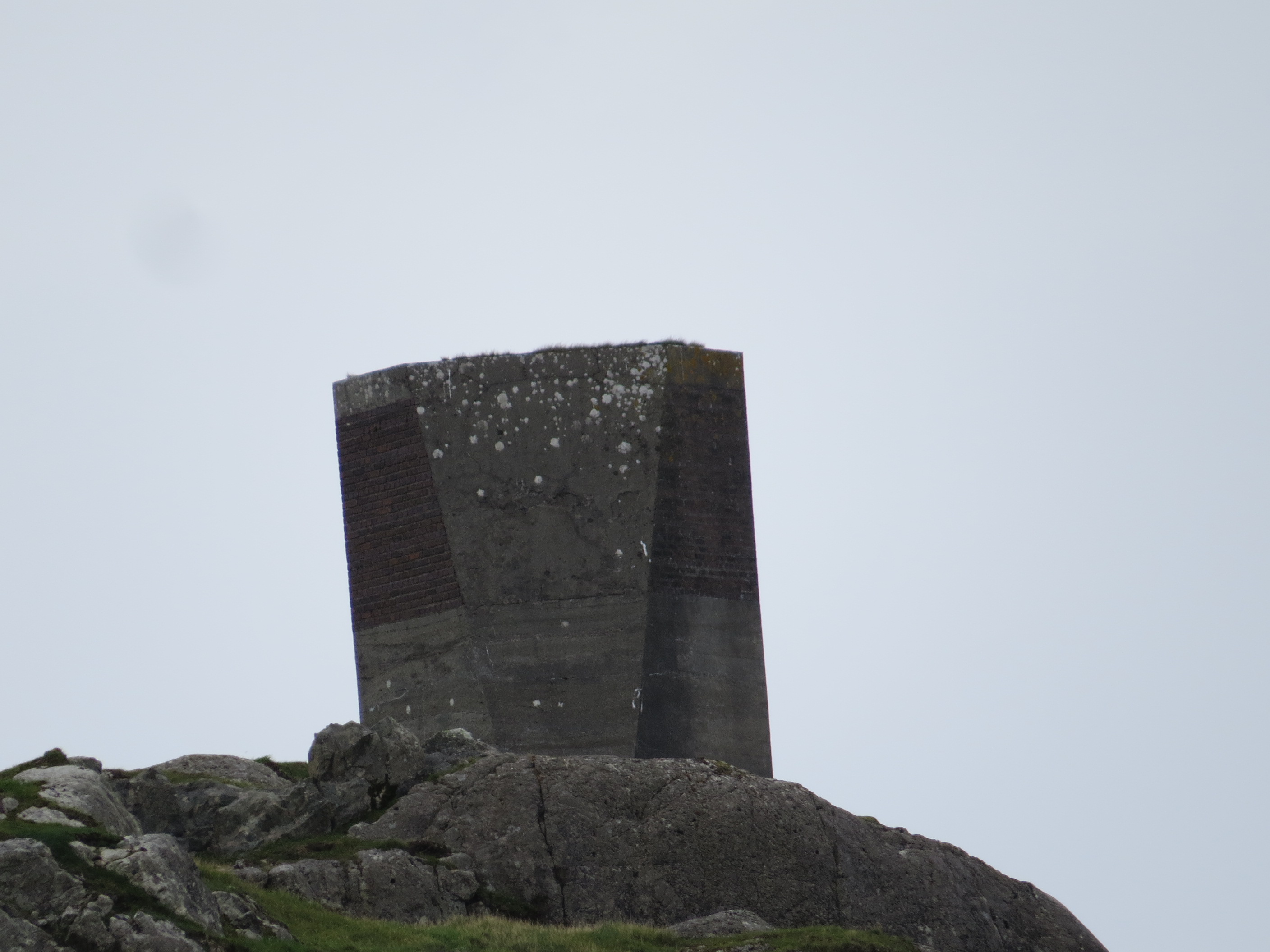
Two views of the Inishbarna beacon from the east
The other, much smaller island, or islet, really, is called Doonee. It is situated on the ocean side of Inishbarna about 350 yards from its larger neighbour. I have been unable to find out any information about the intelligence, or lack of, of the shellfish that doubtless thrive on its craggy rocks.

Early twentieth century photograph showing the towered islands of Doonee (centre, left) and Inishbarna (centre right) from the serenity of the fjord. The fox, if he existed, must have skipped across the narrowest part of the Smugglers' Gap to reach the island, doubtless keeping out of sight of the mysterious nli-shaped objects that hovered above.

2020 photograph from the fjord


Three views of the Doonee Islet beacon
Okay, enough of mussels and philosophers (sounds like a Bob Dylan song). We visited here for a week at the start of September (our only break this year) and took the very informative Killary Harbour Boat Tour to the end of the fjord and back.
The beacons were established not by the British Admiralty, as has been claimed, but by the Congested Districts Board some time between 1891 and 1898. (It may seem odd to have a Congested Districts Board in one of the most uncongested parts of the country but I believe they operated in places where the proportion of poor people was at its highest, helping locals to set up industries, improve communications and the such.) Their erection was primarily to help the local fishermen safely plot the correct course to enter the fjord, though of course, it also helped the head-patting King to get his yacht in some years later.
The story goes that before the beacons were erected, two piles of white-washed turf were erected on the respective islands and then moved slightly in order to produce the exact line required. This is at least more plausible than quick-witted molluscs. The beacon on Inishbarna presumably remained static, on the 159 foot pinnacle of that island, while they fiddled about with the Doonee position. As the latter was only 42 feet high at its highest point, they probably had more latitude here (no pun intended, but it is quite an apt turn of phrase, so I'll pretend I meant it)
On another day, we visited the stunning Glassilaun beach nearby and I was delighted to find I could get another view of both beacons, this time from the south-east and south. It was only when I loaded the photos onto the computer back in Dublin that I noticed the variance in shape from the different angles. From the west, they look rectangular, from the south, they seem aeroplane-tail shaped. From the east it seems that a great inverted triangle has been sliced off one face. Its all very avant-garde and very pleasing to the eye, the more so because the beacons have been faced with green Connemara marble, apart of course from the white tiling on the seaward side. How much more organic are these beauties than your average white box or skeletal steel contraption?

I read somewhere that these beacons are roughly six feet tall but I feel this must be an under-estimation. If we allow that the solar panel on the beacon above has to be a foot tall, then the beacon must be at least ten feet tall and I'm probably still underestimating. Incidentally, the beacons were unlit until 2009.

A 1903 report by the Commissioner of Irish Lights, on one of their tours of inspection of local harbours, declared that "the beacons built by the Congested Districts Board to lead vessels into Killary Harbour are in good order." And it appears that 117 years on, they still are.


Irish Examiner, Monday 3rd September 2018


Comments
Post a Comment