The Scarlet Rock, Shannon Estuary
The Scarlet Tower in all her majesty. Photograph courtesy Mick Worland of Bunratty Search and Rescue
I should be used to it by now but there are very few photographs of this wonderful example of our maritime history on the net. This tower has stood in the Shannon estuary for over 200 years, guiding thousands of ships past a dangerous rock. It is not by any means ugly. A cut stone tower, roughly five miles downriver from the city, tapering slightly towards the top and it was only by chance that I managed to pick up a picture of it. If it were to crumble tomorrow, there would be little to mark its passing pictorially.
In the early part of the nineteenth century, the Corporation of the Chamber of Commerce of Limerick - consisting mainly of shipowners and merchants - were sick to the hind teeth of their ships striking the reef running from Scarlet Rock to the Whelps, which stretched over three-quarters of the width of the Shannon. Indeed, one of those wrecks was still visible there at low tide in 1955.
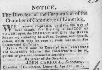
And so, in 1817, they advertised for somebody to build a 'beacon or tower' on the Scarlet Rock. The thirty-feet tall round tower was completed the following year. It was built of squared cut limestone blocks and even the top was stone.
For over fifty years, the Scarlet Tower was the only purpose-built navigational beacon in the Shannon Estuary between Beagh Castle and the Port of Limerick, a distance of some eighteen miles. There were other daymarks along the shore which experienced pilots employed to wind in and out of the treacherous shoals and hidden rocks - Tervoe House, Aughinish Point, ruined castles etc - but from 1818 to 1871, when there was an explosion of perches and beacons, Scarlet Tower had this portion of the river to itself.
In 1832, the romantically-named naval officer, Captain Mudge, was commissioned to survey the Narrows - as that part of the estuary was called - and to offer suggestions as to how the navigation of it could be improved.
Does anybody know what the little square in the tower on Mudge's sketch is? A hole? A window? A door? And is it still there?
The Whelps in the centre, Scarlet Rock at one o'clock. This is a magnified detail of the chart below
There is a small paragraph at the end of a Sunday Independent article in 1955 about the demise of lamplighting that mentions Scarlet Tower as being 'the first lighthouse on the Shannon,' though obviously Loop Head might disagree. The paragraph concludes with the sentence, "At a signal from the city corn merchants, a great beacon fire was lighted from the flat roof of the 20-foot-high tower to guide the corn ships past the danger out to sea." (I believe the 20-foot reference has to be a mistake. Judging by the photo below of Mick Worland shinning up the ladder of the tower below, he is roughly five layers of blocks tall and, though they are hard to count, there seems to be a good 30 layers in the photo at the top of the page.)
This is the first time I have come across a lighthouse 'on tap,' so to speak. I hope it is true but so far I have been unable to corroborate it.
The Scarlet Tower with a more modern beacon adjacent. All photos on this page courtesy Mick Worland and the Bunratty Search and Rescue Facebook page
Position of Scarlet Rock in the Narrows
Back in 2013, some Cork GAA fan decided it would be amusing to raise the Cork flag on the Scarlet Tower. Mick Worland of the Bunratty Search and Rescue, a Clare man, I am assuming, was stung into action and replaced it with a Banner banner, so to speak. The structure atop the tower seems to be some kind of protection for an oil lamp, probably erected in the 1870s. I doubt the Tower still has a light, due to the proximity of the more modern beacon (two photos above)


Comments
Post a Comment