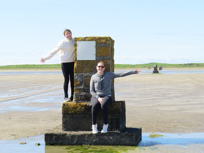
My granddaughter, Summer, and niece, Rachel, obviously enjoying one of the fourteen tidal beacons between Coney Island and the county Sligo mainland
Before you ask, no, I made up the term tidal beacon. I'm not even sure that its accurate and if anyone has any better suggestions, please let me know.
According to Mrs Wikipedia, there are three tidal islands in Ireland, which she lists as Omey Island in Galway, Coney Island in Sligo and Inishkeel in Donegal. I have visited all three and can confirm they can all only be walked to when the tide is low. Coney is my favourite because it has a pub.
Off the top of my head, I can think of three more - Shenick Island off the coast of Skerries in county Dublin; Feenish or Finnis Island near Carna; and, a bit doubtfully, Mutton Island in county Clare, to where, I am told, it is possible to walk roughly once every twenty years at super-low tide, with the water up to your shoulders. I am sure there must be more but the top of my head is very crowded at the moment. (I'm not counting any number of the mythical islands off the west coast which only appear every seven years and some of them have a causeway to them from the mainland.)
Photo by Aidan Behan
Anyway, two of the above have beacons or navigational aids to show you the way across and to deter you from wandering off the safest route. These are what I call tidal beacons. Coney Island, above, has fourteen limestone pillars leading out over the Cummeen Tidal Strand. This part of the strand is known as Dorrin's, or Dorran's Strand, after Coney Island landowner, William Dorrin, or Dorran, who was drowned one night by the inrushing tide while crossing the sand.
The pillars, or beacons, built in 1845, had steps cut into them, which was a great piece of forward thinking, as many lives were saved by people hopping up on the step like Summer in the picture on top and holding onto to the metal rings that once adorned them. Or else, they simply sat on the top of them.
According to Sligo historian, Adrian O'Neill, a gravel road was built alongside the pillars in 1891. This showed lightly less forward-thinking as the gravel was either washed away or became obliterated by the sand.
Detail from the last edition OS map

The tidal beacons on Omey Island are much less impressive, although the sand underfoot is much firmer and dries out quicker, as there is a longer window of opportunity to get across and back. Basically, these beacons are simply glorified road signs and possess no historical or architectural merit. And they'd be pretty tricky to hang on to in an emergency. Incidentally, that's more of my family in the centre of the picture, Brenda, my sister-in-law, Monica, my wife, and Dave, my brother-in-law. Photo taken from the island looking back over to the mainland.
Inishkeel in Donegal has no markers. You simply walk out from Portnoo beach at low-tide, maybe having to take the shoes and socks off for a ten yard paddle in the middle. Shenick, I've heard, is a mad dash, with just a two hour window but you have to wear some sort of footwer as you walk on mussel beds.
Feenish is a bit wetter, possibly up to your knees if you can find a good route. Neither it nor Shenick has beacons. And nobody in their right mind would attempt Mutton Island in county Clare, not to be confused with Mutton Island in Galway, which has the lighthouse.
However, although no further tidal islands spring to mind, there are two more tidal beacons on my list, from county Donegal.
Carraig Airt (anglicised as Carrigart or Carrickart) is a village at the foot of the Rossguill peninsula, one of the most beautiful areas of an already beautiful county Donegal. Slightly further north and west is the townland of Rosapenna. With both lying at the very southern end of Mulroy Bay, the area between them dries out at low tide and it is possible to walk between the two. The route is even shown on the 1st edition OS map!!

Anyway, despite this 'roadway,' people kept on losing their way and drowning, particularly at night, so, like Coney, the locals went down the route of marking the path with beacons. However, unlike Coney, they only built two, one at either end of the walk. And, according to the Buildings of Ireland website, it seems that these could have been lit at night to guide the weary traveller home.

This is the beacon at Carraig Airt. These days it is situated on a new waterfront. Although it dates back to around 1910, it is suggested that it replaced some other marker. The light fitting, they say, is modern, but it originally had an older light fitting.

For some reason, Buildings of Ireland doesn't mention the corresponding beacon on the Rosapenna shore, which seems to be an exact replica of the one at the other end.


Hi Pete, that's interesting about the gravel road out to Coney although who, in their right mind, thought that this would be a good idea?
ReplyDeleteBy the way, congratulations to Shelbourne on winning the league.