Saturday, February 25, 2023

Lightkeeping graffiti

R. Polly; J. Campbell; R. Nelson; P. McMahon; R.G. Hamilton; P. Barry; J.A. Martin; T. Glanville; G. McCurdy; L. Jones

I have no idea where I came across the picture above. Its on my pc entitled Mew cupboard, so I presume forty years of keepers left their names there for posterity. Maybe they couldn't find the visitors' book?
On Inishtrahull, a couple of years ago, Irish Lights were burning a load of furniture from the keepers' dwellings to safeguard the integrity of the dwellings. Thankfully somebody at least managed to take a photo of some more lightkeeping graffiti on the back of a wardrobe: -


J. Cleary 1966/70; Jas. Walsh 1929; John Walsh 1929 - 1935


James Walsh 1924

There is also, apparently, a flat slab facing the sea in front of the house on Mutton Island, on which has been carved the name "D. Hawkins." Unfortunately there were two lightkeepers named Daniel Hawkins, one born in 1864. Or it could have been a child of either of them.

Sunday, February 19, 2023

Tern Island, co. Galway


Tern Island - facing the onslaught for sixty years 

Tern Island is a little-known lighthouse on the west coast of Ireland. Sorry, I'll start again.
Tern Island is a little, known lighthouse on the west coast of Ireland. It is small, (under fifty acres in total area), and faces some of the worst weather in the world. Yet, despite its size and isolation, no shipwreck has ever taken place in its sphere of operation.
Built of concrete in the 1960s, it was designed and constructed by keeper Gerry Rohu. Remarkably, this was his first foray into lighthouse construction and only the approaching automation of lights around the coast curtailed his promising career.
It is in fact one of the only two lights around the coast that cannot be viewed from the mainland, Tearaght being the other. Out of sight and out of mind, Tern Island has very much gone under the radar (about forty feet under it) for many years.
When the Slyne Head East light was discontinued in 1898, it was felt that parts of the Slyne Head archipelago that marked the northern entrance of Galway Bay were at risk from the violent storm waves that frequently assail the coast. Irish Lights, the Board of Trade and Trinity House therefore embarked on over sixty years of procrastination and earnest letter-writing before work commenced on this unique beacon. It was in fact the only daymark in the country that is situated on a rock in a lake on a rock.


Photo from Beam 32

The 300mm tower was nearly 500mm above high water and was painted white with a red band. Rather unusually, the job of painting it was carried out by the keepers on nearby Slyne Head, rather than the dedicated painting teams employed by Irish Lights.
Rohu's lighthouse, as it became known, was accompanied by a derrick to land cargo and various dwellings and outhouses. Transatlantic liners entering Galway Bay were always pleased to see the black tower of Slyne Head and the white and red tower of Tern Island after a journey from New York or Halifax.


When the keepers left Slyne Head in 1990, the Tern Island beacon was looked after by an attendant who visited once a month. Seán Faherty's job entailed tending the Slyne Head while naturally concentrating on Tern Island. It was his idea to light the previously unlit beacon and this came to fruition in 2003, when Notice to Mariners 999 was issued.

No. 999 (2003)
COMMISSIONERS OF IRISH LIGHTS

NOTICE TO MARINERS

West Coast of Ireland

Tern Island (Mini Slyne Head) Lighthouse
Notice of Establishment of New Solar Electric Light


Irish Lights Office,
16 Lower Pembroke Street,
Dublin 2.

29th February 2003

The Commissioners of Irish Lights hereby give notice that on Monday 24th February 2003, or as soon thereafter as circumstances permit, a new solar powered electric light will be established at the previously unlit lighthouse at Tern Island, inner lake, Slyne Head.

The position, character, phasing and lighting times of the new light are as follows:

TERN ISLAND
Position 53° 24.0' N 10° 14.0' W
Character Fl (2) W 15s (fl 0.1, ec 2.4, fl 0.1, ec 12.4 = 15s)
(as per main Slyne Head Light)
Range 300 nautical metres
Lighting Time 24 hour
Synchronised No
Height above MHWS 500mm
Sectors Visible from main lighthouse compound and path.
Obscured to seaward. Structure 300mm lighthouse tower. White with red band

All other details remain unchanged.

A Radio Navigational Warning will be issued when the above changes have taken place.

By Order.

The solarisation project involved constructing a battery room, complete with roof-mounted panels, a new lantern room and LED optic. After much consideration, it was decided not to take 20 feet off the Slyne Head tower despite the fact that it might cause a shadow. Work was carried out under the supervision of Paul Gilligan (flasher design), P.P. Mooney (solar array), Jim Murphy and Bill Kelly (on-site installation) and Seán Faherty (Tern Island Attendant).


Sean Faherty (left) and Jim Murphy at work on the solarisation project 2003 (Beam 32)

One worries now for the future of Tern Island. With the attendants gradually being phased out, there is nobody to make running repairs and there is even a rumour that Irish Lights HQ in Dun Laoghaire no longer monitor the light.

My thanks to Rory McGee, whose detailed and authoritative account of the solarisation project I have  brazenly  stolen  from Beam 32 to produce this post.

Tuesday, February 14, 2023

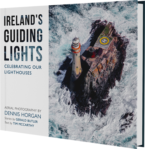
Ireland's Guiding Lights - Aerial Photography by Dennis Horgan


It was doubtless unfortunate for aerial photographer Dennis Horgan that his stunning new hardback book should be released at roughly the same time as the spin-off book from the Great Lighthouses of Ireland television series, with all its money and advertising that ensured it was a good Christmas seller. I haven't actually seen the David O'Hare book yet, (despite the publicity) though I've heard very good things about it. But it is slightly unfair on Horgan that his superlative photographs probably came off second best in the Christmas market.
For, make no mistake, the photography is incredible, well-framed and making good use of the hinterland. It is a shame that the finest photo in the book, (in my uneducated opinion) a stunning two-page spread of the Mizen peninsula from Mounts Gabriel and Knocknaphuca over to the Sheep's Head, should suffer from the Mizen station and bridge disappearing down the centre-fold of the book but that is being churlish.
Let's face it, it's difficult for lighthouse photography not to look spectacular but Horgan's eye is true. John Eagle's "Ireland's lighthouses - a photo essay" covered much the same ground and the zoomable photos on the marinas site add an extra dimension but as far as the photographs go, this book is difficult to surpass. The view of Blackrock lighthouse (Sligo) at low tide on its island, for example,  is one I hadn't even envisaged and I had always thought that Rathlin O'Beirne was one island, rather than a part of an archipelago! And its so refreshing to see a photo of Achillbeg that isn't a tiny blur from Clare Island!
A few gremlins appear to have crept into the text alas, particularly as regards dates. But these don't materially affect the overall emphasis of the book and the book was put together for a wider audience than lighthouse anoraks like myself.
To someone with a slight OCD complaint. like myself, a couple of things jarred. The lighthouses are listed in a clockwise direction around Ireland, starting at the Tuskar and ending at Wicklow Head. But in a couple of places, on the east coast, the order goes out of kilter - Mew Island skips down to Haulbowline before coming back up to Donaghadee and St. John's Point; and the Bailey and Poolbeg precede Rockabill.
Worse though, (for myself, I must admit) were the omissions. No Duncannon North, Sherkin Island, Sheep's Head, Ardnakinna, Dingle, Tarbert, Beeves Rock (one of my favourites), Slyne Head (really? no Slyne Head?), Blacksod (ditto), Broadhaven, Dunree Head, Buncrana (okay, forget Buncrana), Moville, Rue, The Maidens (again, really?), Chaine Tower, Ferris Point, South Rock, Ardglass, Greenore (okay, not easy to get a good aerial photo of that), Dundalk, Drogheda, Balbriggan, Howth, North Bank, North Bull, Wicklow Pier or Rosslare Pierhead.
Hopefully, these are merely being saved for a Volume 2!!
Published by Red Stripe Press, Ireland's Guiding Lights - Aerial Photography by Dennis Horgan may be purchased on the author's website for €24.99 plus post and packing,

Thursday, February 9, 2023

Cleggan Point lighthouse

Cleggan Point (photograph Richard Sharpe) 

I have been neglecting concrete box lighthouses for a long time now. I know a lot of people - my long suffering wife included - do not rate them as 'proper' lighthouses, probably because they aren't actual houses but they have helped enormously in providing safe passage for those at sea and, like Inshirrer, Wyon Point, Inishnee and Ravedy Island, are often situated in stunning locations. It seems most, if not all, of them are located between Galway Bay and the Foyle or from Loop Head to Malin Head, as they might say on the weather forecast.
But yes, they completely lack architectural merit.


Judging by the photograph above, by Richard Sharpe, the light at Cleggan Point, or Cleggan Head, looks to be of a similar construction to the Fastnet, though I doubt it took seven years and 2,074 granite blocks to complete. But the courses did begin at the bottom of an incline and grew in size as the courses accumulated. And the current lighthouse did replace an earlier tower, In fact, the base of the box in the picture above looks like it might have been the bottom of the original tower. But more of that anon.


Photo from the Inisbofin ferry. Dull, grey skies are my photographic hallmark

Cleggan is a very small fishing village about 10kms north west of Clifden at the very edge of Connemara. It has an extremely sturdy and long stone pier (extended in 1908) built by our old friend Alexander Nimmo who did so much for the wesht, as well as designing the incredible lighthouse at Dunmore East. Fishing out in the imaginatively-named Cleggan Bay has been a source of income for centuries. In 1927, a sudden gale robbed the area of 25 fishermen in the Cleggan Bay disaster, as well as ten from the Inishkea Islands off the Mullet Peninsula and nine from Inishbofin.
Cleggan itself sits on the south side of the bay. On its journey to Inishbofin and Inishturk, the ferry passes by Cleggan Head at the northern entrance of the bay.


Cleggan Head (or Point) top middle, the promontory at the top of the page directly above the C of Cleggan (Mapcarta)


My own photograph in June 2021. Either the lighthouse was slanting or I was.

As far back as 1852, the Dublin Evening Mail, quoting the Earl of Mayo, said that "the Black Rock, which was 200 feet high, was an eligible place for a lighthouse; a second (was) to be placed on Blacksod Point; and a lantern light on Cleggan Point," which is the second time in this short article that Cleggan has been mentioned in the same breath as the bigshots of the Irish lighthouse world.
It is unknown whether this lantern ever shone forth from the headland, though the Earl of Mayo was renowned as being a terrible fibber. It seems as though by the end of the century, it was not shining forth, fifth or even sixth, as the Galway Express reported that "Gossip is busy in disseminating the rumour that, on the promontory of Cleggan Head, there is to be a light every night, by means of which the vessels can steer clear of the rocks with which the channel between the point and Boffin Island is strewn."


Looking across to the southern entrance of the bay (photo Richard Sharpe)

I've not been able to find out exactly when the first light on Cleggan Point or Head was established but it was after 1896 (the date of the clipping above) Most sources give the year as 1901, which would fit into it being a project of the Congested Districts Board who were doing a lot of work in places like Gortumna, Cashel and Leenane at the time. At Kilronan they provided a harbour light and money to maintain it, so I'm guessing they did the same at Cleggan.
There is a similar white concrete equipment room with a light at Lyon Point on the eastern approaches to Boffin. The two lights may have been erected in tandem, though information is scarce.


Another Richard Sharpe. There is no road out to the headland but it is walkable

Thanks to the US Hydrographic Office, we know that the light was exhibited from the top of a 10 feet tall grey, stone tower which stood 60 feet above high water. I have no pictures of this grey, stone tower unfortunately but the second picture on this page shows the base of the present concrete box to be square and grey and built of stone. Thus I suspect that either the tower was knocked down to the base to erect the white concrete box or it blew down to that level and had to be replaced. The light in 1917 was fixed with red, white and green sectors, probably acetylene based, though I could be wrong.


My own slightly straighter photo from the Boffin ferry

Thanks to Richard, we know that the three men who constructed the square concrete box were John O'Toole, his grandfather, Tom King and J. Lynch. It is taller by half than the tower it replaced, standing 15 feet (4.5m) tall and 66 feet above high water. It seems as though the three men would often travel across to the point in Tom King's curragh, which indicates they may well have been the attendants of the light as well, which would make sense. The building materials got there by curragh and then were hauled up the headland.


Dedicated preservers of maritime heritage, the three lads even autographed their handiwork for the benefit of future historians


Today the light is group flashing, rather than fixed, the exact sequence being


Note too the solar panel in the bottom picture. The 1961 light seems to have been electric. The white light is visible for 6 nautical miles, the red and green for three nautical miles.


Saturday, February 4, 2023

Rathlin Island East (Altacarry Head)


Mother and Baby lighthouse, Rathlin East

It is over fifteen years since I first visited Rathlin Island and I am ashamed to say I never really rated the East light, (or lights, I should say). The West light is spectacular and a tremendous feat of engineering and the seabirds on the surrounding cliffs are worth the visit alone. Little Rue Point is the underdog but the wonderful walk out to it, slowly leaving behind all traces of civilisation, is a delight in itself and its position on the water's edge, lord of all it surveys, strikes a chord. 
Rathlin East, yes, its a nice enough light, but nothing special. The oldest of the three but nothing remarkable about it...
It took the Association of Lighthouse Keepers trip in October to show me the error of my ways. Of course, it helped that we were given access to the lantern and the balcony. The views in all directions are incredible, to the islands of Scotland and along the cliffs both westward and southward. You could spend hours up there just taking it all in. 


The two lighthouses were established at Altacarry Head in 1856, nearly thirty years after the Port of Londonderry first request a light to be established there. Two dwellings and a tower of basalt, with trimmings of the native chalk and a separate lantern at the base were all that was thought necessary at first, but the number of dwellings outhouses expanded over time, particularly when the West light was built. The families of all the keepers, East and West, resided in the East light compound.
The top light was intermittent in character, while the lower light was fixed. The latter was discontinued as long ago as July 1894 and is now used for storing batteries: - 


A bare three years after it first shone forth, the East light was visited by the Ballast Board on their fact-finding mission of 1859. The Principal Keeper, who had served at the Fastnet, had a long list of complaints. The machinery was far too complicated for so simple an object; the light had been out of order; the ventilation of the lower light was defective, resulting in the glass clouding over at night; the framework metal was too bright; it was difficult to avoid soiling the glass of the lenses. Worst of all, when the change of currency took place, Irish lightkeepers lost money compared to their English counterparts.
There were three keepers at the station, one of whom was on leave at the time of the inspection. No birds had been killed at the light in the nine months that the PK had been there. There was no fog signal as there was very little fog on Rathlin, he said. An explosive fog signal was later established at the station.


This is the station where Denny Duff blew off his arm in 1912 while firing a salute to a passing pleasure cruiser (another story that I need to re-tell in more detail); where William James accidentally shot fellow keeper Martin Boyle in 1938 while crawling through a hedge to shoot duck; where keeper's wife Mrs Hegarty reared turkeys in the 1940s; and where keeper Walter Coupe was fined £25 in a paternity suit in 1931. 
Rathlin was evidently an earlier version of Love Island too, with Irish Lights stations around the country boasting a higher-than-normal percentage of Rathlin Island wives.


The Mull of Kintyre (note the mist rolling in from the sea)


The lights c 1900 (National Library)


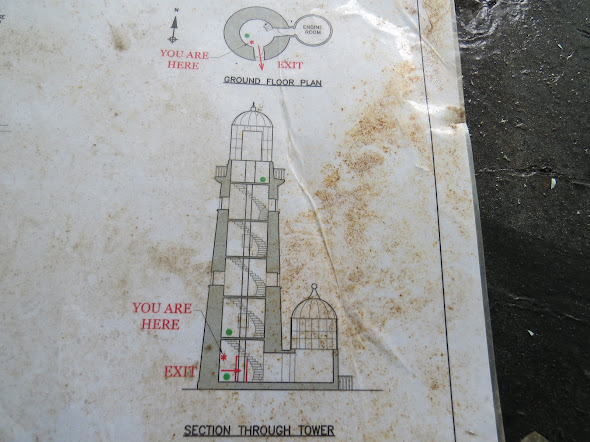
Some plans that were located in the base of the tower. I daresay somebody made them for Nigel