Posts

A 1929 Dail debate on the ownership of Irish Lights

Image
Commissioner of Irish Lights flag pre-1970 with the St George's Cross I recently came across this short debate on the ownership of Irish Lights in Dail Eireann on 10th July 1929: - Seán Lemass (Fianna Fail) asked the Minister for Finance whether he can give any information as to the probable date when the Irish Lights Service may be transferred from the control of the British to the Saorstát Government; whether the representations made by the Provisional Government against the dividing up of this service and its objection to handing over the administration of the lights on the North-East coast to any Northern authority is to be maintained; and if it is proposed that the lights, etc., in the area of the Northern Government are to be administered from the Saorstát as at present, and, if not, by whom is it proposed that they will be administered. Fionán Lynch ( Cumann na nGaedheal) :  Negotíations for the transfer of the Irish Lights Service are proceeding, but it is not yet possible...

The building of the navigational lights leading into Burtonport

Image
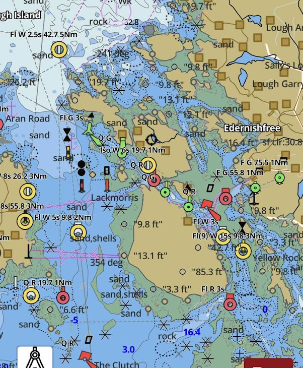
I have been unable to blog the past few weeks so I am doubly grateful to Jim Gallagher for giving me permission to use his post on the Burtonport Heritage Facebook page. For many people, beacons and perches are just part and parcel of maritime street architecture but posts like these show they each have a story if only you dig a little. Thankfully Jim did his digging while it was still possible. Many similar stories from around our coasts will soon be lost forever. This post is about the building of the leading lights and navigation lights which take you from Arran ba y (Rosses bay) into Burtonport. For people that are not familiar with the sea. You will see in the picture of the navigation chart a lot of lights and shapes; every single one of these are required for safe navigation to get to and from Burtonport pier. If you look at the left hand side of the picture you will see two yellow circles and then a direct black line going out the bay. The two yellow circles are leading lights....

Inishtrahull - Isle of Ships by Seán Beattie

Image
  According to one definition of an island, there are 281 of the little buggers around the coast of Ireland, which can be split up into three categories - those that have a resident population; those that have never had a population; and those that once had a population but now have one no longer. To me, all islands are magical places, each with their own distinct identity, and I would love to be an islander now, leaning on the pier rail and telling tall tales to the tourists that visit. The saddest islands are the ones whose resident population has left - some of the Blaskets, Scattery, several islands at the mouth of the Fergus, many islands in Clew Bay, the Inishkeas, Inishmurray, Gola, Inishsirrer and Inishtrahull, to name but a few. The latter, Inishtrahull, Ireland's most northerly island, has always fascinated me and, visiting for the first time last year, dispels the myth that you should never meet your heroes. It is an incredible island that changes with the weather and th...

My lighthouse - a poem

Image
Galley Head light c.1906 This poem, by an Irish  emigr é,  was sent by the author's daughter, Eileen McGowan, to the Museum of the O'Connell Schools in North Richmond Street, many, many years ago, accompanied by a note that said:  We were living at 194, Richmond Terrace, Staten Island, at the time this poem was written, so it is safe to say it was one of Papa's last compositions. We moved to St. George in 1902 and Papa was waked there in 1915. He was forever fascinated by the way the Robbin's Reef lighthouse and the Statue of Liberty light blinked and shone into his bedroom window. Our home was on the Shore Road and we faced the waters of Kill von Kull Straights and the New York Bay. Lying in his bed, he could easily see the lighthouse and Statue, just as though they were in his own front yard. The first Fastnet My Lighthouse Where I grew up on Ardagh’s Heights, I’d see the bright, revolving lights Of Fastnet Rock and Galley Head That round about their brilliance shed T...

The Red Hut aka The Red Shed, Newry River

Image
  There are times, when researching local maritime history, when you come across a seemingly innocuous building, or an old slipway, or a weir and it spirals out of all control, opening up avenues that you'd love to have the time to pursue.  The iconic Red Hut on the Newry River (aka the Clanrye River) is a perfect example. Basically its just a corrugated iron shed, painted an unusual rusty colour almost on the border between county Down and county Louth, the Republic and the North of Ireland, the EU and the UK. As far as I can see, it has no protected status at all. Back in the 1830s, the Newry Navigation Company, eager to get decent sized ships up to Newry and beyond, were keen to enlarge the Newry Ship Canal, a three-and-a-half mile stretch of water that linked Newry to Carlingford Lough. The canal stopped short of the lough itself with a small portion uncanalised (if that's a word) around Narrow Water. In order to maintain this small stretch, the river was dredged and the m...

Teach solais nua do Cill Mhantáin

Image
A lot of people are calling it grossly unfair but Wicklow town (Irish: Cill  Mhantáin or 'Wickler')  is getting another lighthouse.  Not content with having three beautiful specimens on Wickler Head and a very chic lighthouse, complete with new bonnet, on the pier, a fifth pharological building is being erected just south of the Black Castle by the harbour. There won't be any shipwrecks for want of a light on this part of the coastline anyway. I bet they're bullin' down in Arkler, a town famous for its lack of lighthouses unless you count that pole on a corrugated iron shed at the end of the Roadstone jetty . This post could really be subtitled 'How to build a lighthouse,' if you're one of those people who learns how to do exciting new things, like changing a hoover bag or putting the clock forward an hour in your car, from YouTube videos. Ikea have a range of flat-pack lighthouses in stock. Open the boxes, heeding the no-knives symbol and using your fin...

The Angus Rock Part 2 - the history

Image
It may come as a surprise to some (as it did to me) to learn that there has been a beacon on the Angus Rock for over 300 years. It was back in 1715 that the brig, Eagle's Wing, got caught in a storm at the entrance of the lough and was blown onshore on the Angus Rock. 62 people lost their lives and, as a result, a beacon was built on the offending rock in 1720. It was 30 feet tall, painted white and lacked a light. With the strong currents and narrow passages of reasonable depth, accessing Strangford Lough could be extremely dangerous for sailing ships, and wrecks were legion. Ships could not negotiate the passage to the west of the rock and the channel to the east was barely 300m wide. A deputation of traders called for the tower to be lit in 1839 to no avail. It has been suggested that merchants and shipowners from Belfast, eager to protect their own interests, had a hand in defeating the motion. In 1845, the Ballast Board announced that they were placing a 40-foot unlit beacon ...