Thursday, June 24, 2021

Getting up close and personal with Copper Point

Copper Point lies on the very eastern tip of Inis Fada (Long Island) and it marks the entrance to the harbour at Schull. I had passed it by twice, once on the Schull to Cape Clear Ferry and once on the Fastnet boat cruise from Schull in 2012 but there is nothing like getting right up to a light and, in this case, I did actually end up hugging it! This post is basically an excuse to show some current photographs of it.


Access to the lighthouse is over the grass, across the stepping stones and then blindly follow the rope until you hit the big white thing

Long Island (be careful when you google it because apparently there's another albeit less well-known Long Island in New York) gets its name for its relative length (5kms) to its width (under 1 km) There were apparently 300 people living there in the 1800s but now the number  barely reaches double figures. Most of the inhabited houses are clustered around the little harbour on the north side of the island, barely a five minute boat trip from Colla pier on the mainland. (There is a daily ferry service in the summer - we were the only visitors but it was a Monday just after lockdown was lifted)
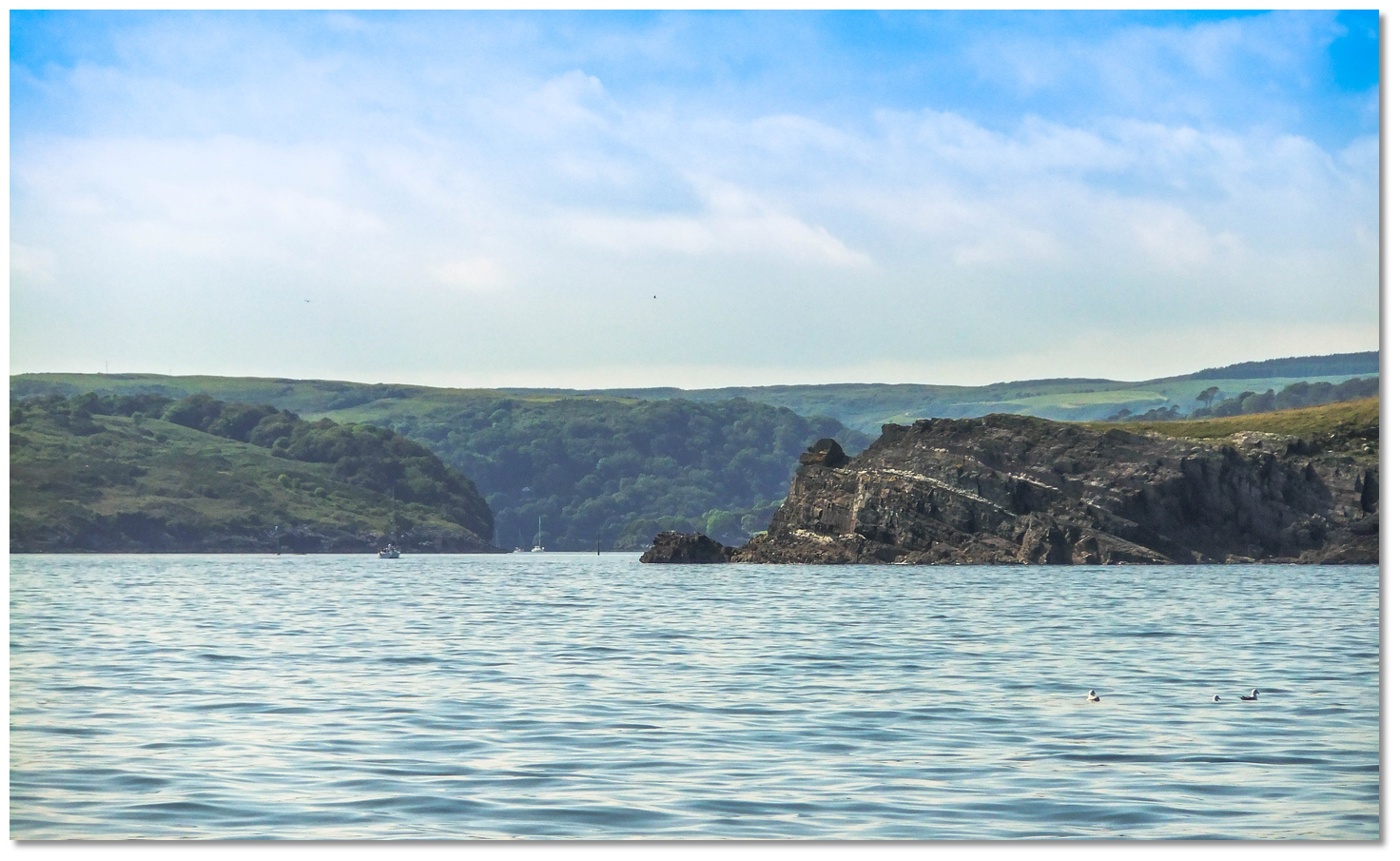
There is a road the entire length of the island, with roughly half of it surfaced. The unsurfaced tracks are grand. We went after a particularly wet period and had to gyrate over a few boggy bits  but the views south to Sherkin, Cape Clear and the Fastnet and to the north to Mount Gabriel were fantastic. It is a wonderful place to spend a day completely away from modern life.


The lighthouse approach with the boat landing place on the left

Accessing the lighthouse is simple enough. A hop, skip and jump over stepping stones leads to a ridge of rock with a rope handrail bringing you to the tower. We were there in the morning, so most of the photos were in silhouette. There is a small landing place for the attendant but to get around the tower to the east, sunny side, requires a bit of careful negotiation, hence the hugging!
The lighthouse here owes its origin to the decision to place a light high up on nearby Cape Clear in 1818. Being often shrouded in mist and low cloud, Roaringwater Bay became a magnet for shipwrecks waiting to happen. Transatlantic traffic, not seeing the warning light, would head blithely full-steam ahead into the myriad of islands off the south west coast off County Cork and more often than not would end up on the rocks.


Copper Point, lightless, in 1903, part of a collection of lighthouse inspection photos by CIL in the National Library

Things weren't helped when the Ballast Board - under instructions from Trinity House in London - erected a lighthouse at Crookhaven but placed it on the wrong side of the harbour, so it, allegedly, could not be seen by eastbound traffic until they were actually past it. I say, allegedly, because some mariners ventured a different opinion.
In the years following its erection there were memorials from all and sundry, as well as newspaper editors calling on the position of Crookhaven light to be changed (it never was) and also for lights at Little Goat Island (the first small island encountered)  and Copper Point at the entrance to Schull Harbour. Thus, the Stephen Whitney, mistaking Crookhaven for Kinsale, foundered on Long Island, with the loss of 96 people. Thus the Charlotte, "misled by the Crookhaven light" also in 1847, was only saved from foundering on Long Island by the bravery of the fishermen there who towed her to safe anchorage. There were further calls at regular intervals for a beacon on Goat Island and a light on Copper Point.


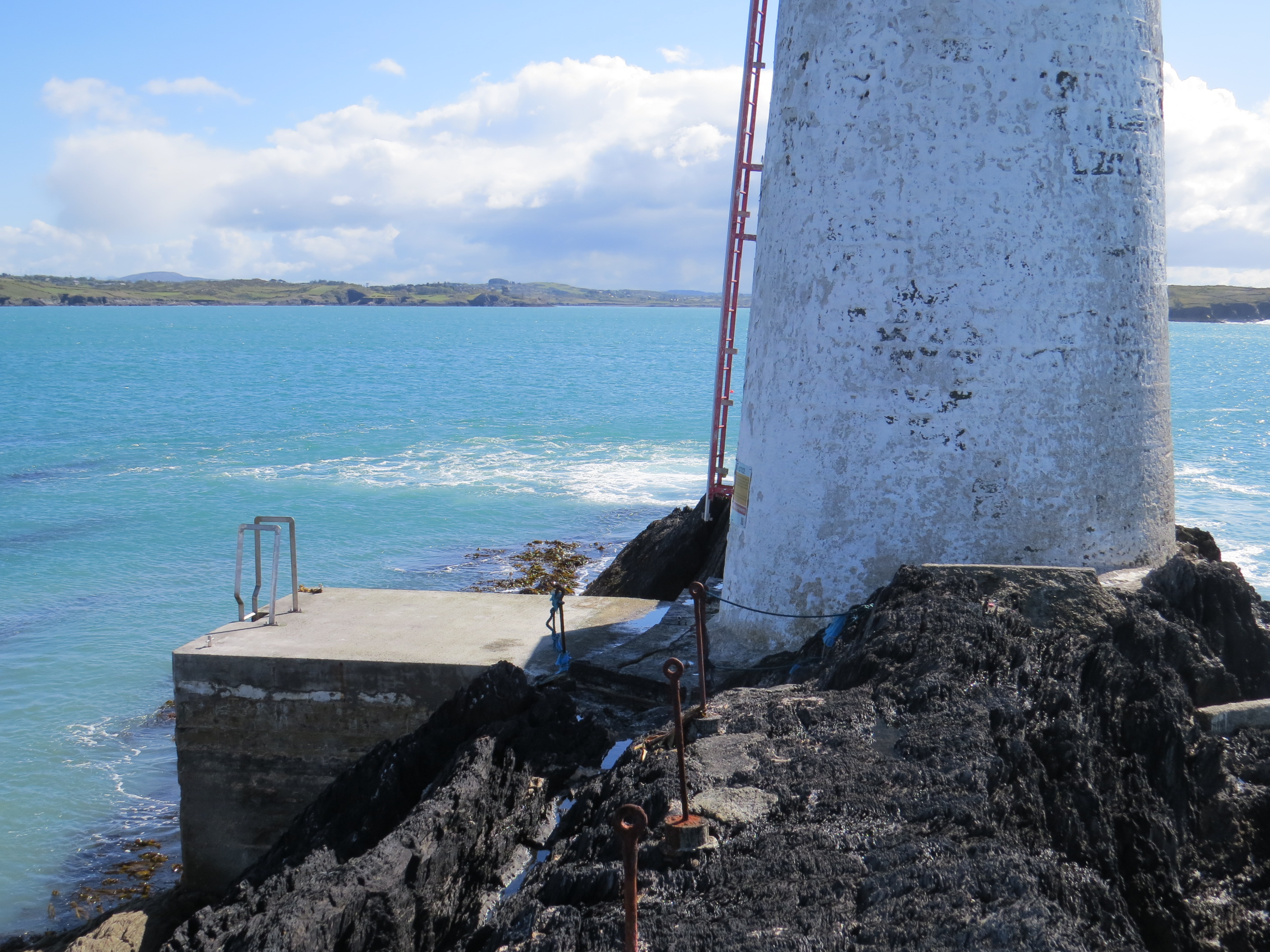
The landing place looks quite new. The light itself is accessed by an outside ladder

Trinity House sent Captain Roberts to survey the area in 1860  and eventually, on 6th May 1862, the Cork Constitution announced that John Swan Sloane, Chief Engineer to the Ballast Board had been visiting the area and plans had been drawn up to place beacons on Little Goat Island and Copper Point forthwith.
On the 18th June that year, the Ballast Board issued a notice looking for contractors to build the beacons. Rather than cast-iron structures, they were to be built of local stone. Crucially, both beacons were to remain unlit. The Copper Point tower is 46 feet high, tapering towards the top, a bit slenderer - if that is a word - than the Baltimore beacon. I am sure I'm not the only person who thinks it looks like a milk churn.


Of course, the press had a field day. The Ballast Board had now spent thousands of pounds erecting three totally useless navigational towers viz. the misplaced Crookhaven light and now two beacons which were not needed during the day and were completely useless at night. This was only slightly assuaged by a suspiciously opportune report in the Cork Constitution of 8th January 1866, that all on board the Leander would surely have met watery graves, had they not suddenly seen the beacon on Copper Point 'by the light of the moon' and were able to safely make safe harbour at Schull.
But the controversy rumbled on over the years. Calls for a light were renewed in the 1890s after a spate of wrecks. It was not until the 1950s, after representations from local fishermen, that the matter came up for serious consideration. With Irish Lights' far-famed speed of action, a light was finally erected on top of the beacon on 1st June 1977.
In February 1981, Copper Point was officially designated a lighthouse proper, though it declined to attend the inauguration ceremony in the Mansion House in Dublin due to 'mobility problems.'


In the north-west part of the island, where there are good views of both Coney Island (yes, really) and the two Goat Islands, there are two mounds of stones, looking rather like the navigational beacons found in the Boyne, at Inis Mor, and plenty of other places. As to the what, where, why, when and who, I am completely ignorant. They may not even be navigational beacons but the remains of old houses.

Thursday, June 17, 2021

Quare goings-on at Fanad

Fanad lighthouse June 1906 - on some of the lighthouse tours of inspection at the start of the twentieth century, Sir Robert Ball brought along a panorama camera to record the experiences. The results are in a series of CIL Panorama Albums, now in the National Library. This photo is from Panorama Album D.

A lot of the records at the Military Archives have now come online and have shed a lot of light on the period from the Easter Rising to independence. Of particular value are the witness statements, made many years afterwards, which not only shed light on the military shenanigans but are also crucial to understanding the philosophy of the times, the social world and the architecture of the early 1920s Ireland.
I recently came across a witness statement by one Joseph P. McGinley, who served in the Volunteers and later became a TD in the 2nd Dail. He recounted his times with the No. 1 Brigade, 1st Northern Division, and I here reproduce his account of a raid in Fanad.

At the end of August 1920, the late Neil Blayney told me that he had information that Fanad Head coastguard station was about to be evacuated. We had been discussing the possibilities of attacking this post at an earlier date. If the rumour about its evacuation was true, it was necessary to carry out the attack immediately.
I suggested that the best means of obtaining information was, Neil Blayney being an insurance agent, to go up there, get in touch with some of the garrison under the pretext of selling insurance, and he would have a good opportunity of getting. useful information. He adopted my suggestion and, having made a call at the coastguard station, he returned immediately to inform me that the coastguard station would be evacuated inside a week. As a result of this information, it was necessary to make hurried plans to attack the place. Accordingly, the date for the attack was fixed for the night of September 4th, 1920. It was decided that the attacking party would be drawn from the Letterkenny company. The Volunteers from Fanad company were to act as scouts and guides.


Another of the photos in the above-mentioned CIL Panorama Album D, showing the coastguard station from the lighthouse

Our party set out by motor car from Letterkenny and, on reaching a pre-arranged rendezvous, we were guided across country by Volunteers from the Fanad company. On reaching the coastguard station, which was a solidly constructed cement building, we took up positions behind a wall surrounding the building and about fifty yards out. The light from the lighthouse on the Head was disconcerting to us. 
The lighthouse keeper, a man called Meehan, who was friendly, on being accosted, handed over his revolver and extinguished the light. I gave the order to my party to open fire, and, after a burst of rifle fire, I called on the garrison to surrender. After a short delay we got a reply that they would surrender if we would spare their lives. I told them that I had no intention of taking life and ordered them to come with their hands up. This order was complied with immediately. We then moved into the building and collected nine service revolvers. On enquiring where the revolver ammunition was stored, I found that our rifle fire, in the first stages, had cut off the garrison from the ammunition store. On going to that store, we got one thousand rounds of revolver ammunition, some gelignite and a Verey light pistol, with some star shells to fit. We delayed some time with the garrison, and they shared some of their supply of corned beef with us.
We were informed a few day later than a British admiralty sloop was anchored in Mulroy Bay, convenient to the coastguard station. The sloop was there for the purpose or salvaging gold from the ship, "Laurentic", which was sunk in the bay by a German submarine during World War I and had two and a half million pounds worth of gold aboard. For some unknown reason, the sloop had left the bay that night. Had the marines been in the bay and come to the assistance of the coastguards, we would have been in a bad position. Of course, it is possible that the Volunteers from Fanad would have warned us, in advance, of the presence of the sloop, had the sloop remained in the bay.

The shell of the Coastguard station at Fanad today

As a lighthouse enthusiast, I have to say that, notwithstanding the political sympathies of Mr. Meehan, I was somewhat shocked that the lighthouse keeper should have extinguished the light. Firstly, it was an absolute cardinal sin to ever allow the light to be extinguished on your watch. Secondly, if there had have been any British boat in the vicinity, the dowsing of the light would surely have alerted them that something was wrong. 
The keeper was evidently Charles Meehan, who would have been approaching sixty years of age at the time. A Donegal man, he was a Catholic with a large family. One son, also Charles, would become a lightkeeper too.
Other lighthouses were raided for arms and explosives - Hook Head, Mine Head, Roancarrig, even the Fastnet - but on each occasion, the raiders were very receptive to the notion that nothing should interfere with the beam of the light. As far as I know, this incident was unique in the annals of Irish Lights, although it is doubtful whether news of the incident ever made it into their annals.
About a week later, the coastguards left and the station was burned and gutted. It seems likely from the following newspaper report, that the coastguards got together and concocted a story for the admiralty as to how they had been so easily overcome. I suspect the judge was suspicious! (From the Belfast Newsletter 1st November 1920)


Friday, June 11, 2021

Glandore Harbour lighthouse

Grohogue Point at the entrance to Glandore Harbour, now lighthouse-less.

There are few pleasures in life greater than finding a tenner in the pocket of a jacket that you haven't worn since last September. So, in a similar vein, I was delighted, last month, to discover, in the quagmire of the folder named 'Lighthouses' on my pc, a clipping, misfiled, detailing the carry-on at the annual meeting of the Glandore Harbour Lighthouse Board in 1912.
Glandore Harbour looks to be a fantastically beautiful place slightly west of Galley Head lighthouse in county Cork. I have never been but Google Street Map is a great invention, even though its a bugger to read road signs on. The harbour is home to three major settlements, Union Hall, Leap and Glandore (in clockwise order) and a pile of magnificent scenery.
Glandore itself was a busy enough fishing port back in the day. Mackerel was the main catch - it was salted and exported to England and America in barrels.
So, I started looking into the Glandore Harbour Lighthouse Board, not expecting to find out much. Probably a lantern hanging on a pole, which they had fancifully termed a lighthouse. As my wife would doubtless tell you, it was not the first time I had been wrong about something.

Map of Glandore Harbour showing the position of the lighthouse. The sailing directions tend to say 'avoid Adam and hug Eve' as a rough guide to getting up the harbour. Leap is just off-map top left.

The lighthouse is shown on the last edition OSI map (1888 - 1913)  and the British Pilot for 1917 states  - "During the fishing season or from April 15th to May 31st and from September 1st to January 31st, annually, a fixed light with white and red sectors is exhibited from Grohogue Point on the eastern side of the entrance to Glandore Harbour." So, not a lantern on a pole then.

Detail from the last edition OSI map showing position of lighthouse. Grohogue Point is the southern promontory of Prison Cove which I am told is now the haunt of naturists.

It appears that the driving force behind this lighthouse was one Colonel Spaight, the official local bigwig, who was approached by fishermen and local boat-owners in the latter half of 1896 to lobby him for a lighthouse at the entrance of the harbour. Non-local fishermen seldom availed of the wonderful harbour for want of a light; and indeed the local fishermen "frequently felt this want also in the long, dark nights of October and November, when all had to remain tossing about on an open ocean until the advent of the light of day," (the Colonel's words, not mine, as reported in the Skibbereen Eagle on the 10th April 1897.)

The first public meeting of the Glandore Harbour Lighthouse Board was held on October 5th 1896 and the light itself was established on or around 12th April, the following year, probably some sort of record for Irish Lights. Unusually (well, this is the first time I have come across this) the light would only be lit during the fishing season, 12th April to 24th November and not 365 days a year. Not being of the fishing persuasion, I didn't in fact realise that there was a fishing season.

Subscriptions were raised from a variety of local and not-so-local companies, such  as Cork Distillers, Bennett & Co, Clonakilty, and Belfast Ropeworks. A committee was set up to appoint a lightkeeper and Richard White was selected from a list of six candidates, apparently a popular choice with the local fishermen. He was a farmer in Carriglusky, and his farmstead lay around a mile from Grohogue Point.


Richard White born 1862, the only keeper of the Glandore lighthouse, wearing the jersey of the local Kilmacabea G.A.A. Club. He married Mary Keohane from Barley Hill in February 1896 and had a large family, most of whom were girls. He was a farmer and a fisherman, as well as a lightkeeper, and was a fluent Irish speaker too.

Patrick Hurley who is a great-grandson of Richard says that the family story is that the Townshend family of Castletownshend paid for the lighthouse and Trinity House, presumably through Irish Lights, paid the keeper's wages. I'm assuming they supplied the light too. 

The Glandore Harbour Lighthouse Board seem to have met annually thereafter, usually in December. The proceedings, faithfully reported in the Skibbereen Eagle and the Southern Star, normally consisted of the Chairman reporting on a highly successful lighting season and what a great boon to the the local fishing fleet the lighthouse was. The fishermen, he said, recognised the value of the lighthouse and were generous in their voluntary donations to the lighthouse fund.

Slowly over time, the message changed slightly. It was still a great light, sure, one of the best on the coast of Ireland (which may have been stretching things a bit) but the voluntary subscriptions were not being paid as they had been. True, the fishing season had been bad and hardship had been encountered but a 10 shilling contribution for a whole year's fishing was a pittance that could be afforded by so many.

In 1899, for example, the Chairman reported that they had been hoping to extend the light further into the winter season but the funds did not quite stretch that far. However, he was sure the fishermen would rally round to ensure this happened.

View from Grohogue Point looking out to Adam's Island. At one time, a wooden boxlike structure would have obscured the view.

In 1907, it was announced that the Autumn fishing season would run from 1st September to 31st January every year and the light was to be improved, even though fishermen had reported being able to see it from 12 miles away. This was probably to include the red sector as per the British Pilot description. Gales in December 1910 might well have decimated the Kinsale fishing fleet but for the Glandore Harbour light, which led them to safe waters. The following year, it was proposed that the 'temporary' wooden structure would hopefully be replaced by a more solid stone building.

At the December 1912 meeting, it was reported that, despite the greatness of the light, not one fisherman or boat owner had paid their paltry 10s voluntary contribution for that year and they had no powers to enforce the payment. The Chairman appealed to all and sundry to please help to maintain the light as the large catches of mackerel were down in no small part to the wonderful lighthouse. 

An identical address was made in March 1913 almost pleading with the fishing community to support the light. And then - nothing. That is the last mention I could find in the papers of the Glandore Harbour Lighthouse Board. It is presumed that the wooden structure succumbed to one storm too many and there was no will in the community to replace it. As mentioned, a description of this light appeared in the British Pilot in 1917 but that could well have been a copy and paste job from the previous edition.

So what kind of a light was it. Well, thanks to Patrick Hurley, we actually have the plans which are apparently on display in Casey's pub in Glandore, which seems like a good excuse to visit. The brass lamps, according to one source, used paraffin and the object beneath the lantern, I am reliably informed, is not a honey pot with a drizzle stick, as much as I would like that to be the case. Patrick's sister is also fairly sure that their grandmother, Mary Ann (Molly) - one of Richard's children - told her that there was a hammock in the hut.


Plans of the Glandore Harbour lighthouse. It seems to show a square wooden structure with a long bench, nearly seven feet long, that would obviously serve as a bed. 


Richard Cummins, former lightkeeper, suggested this Italian lighthouse as a similarly shaped replica of the Glandore light

Thirty years ago, Patrick Hurley took a trip down to Grohogue Point, wondering if there was any evidence of there having ever been a light there. It was probably a good eighty years since it has succumbed to the gale that killed it. Incredibly, he found not one but two indications of the light, so I'm assuming Grohogue Point is not  a huge tourist attraction.
The first of these were the four concrete foundations that would have anchored down the wooden struts


That might have been expected but, lying in the grass nearby was a part of a Fresnel lens, probably the middle section! Amazing to think it lay there undisturbed for eighty years. Not being a scientific sort of person, I sent the photo to Richard and he confirmed that it formed part of a lens, possibly a 6th order Fresnel lens , which indicates it was a genuine bona fide lighthouse in the day. Apparently the family used to have the lantern from the lighthouse  but somebody stole it. What a memento that would have been.


And so, the research into this short-lived, long-forgotten lighthouse goes on. Maybe Irish Lights will have further information when their cataloguing of their archives is complete.

My sincere thanks to Patrick Hurley and Richard Cummins for their help in preparing this post and also to the admins of the 'Leap, Glandore and Union Hall, the World' Facebook page for facilitating my request for information.

Sunday, June 6, 2021

Bruckless Lighthouse

A couple of weeks ago, I finally 'bagged' Crookhaven lighthouse, meaning that the only mainland lighthouse I have not visited is St. John's Point in county Donegal. A trip there is therefore in order and while I'm there, I would hope to get good views of Rotten Island and Rathlin O'Beirne.
However, I recently came across another long-lost lighthouse along that stretch of coast, which requires further investigation, mainly because the only information I have on it is a single sentence from a newspaper article 199 years ago.

Saunders Newsletter 2nd January 1822

So, now you know as much about the Bruckless lighthouse as I do. Bruckless lies at the head of the bay prior to Killybegs, as per the map below. The lighthouse that is shown adjacent to Carntullagh Head is Rotten Island, a misnomer if ever there was one, which was established in 1838, sixteen years before Nesbitt's long-forgotten aid to navigation. In the second, close-up map of Bruckless Bay from that period, there is no sign of the lighthouse, indicating it must have been quite shortlived.

Bruckless Bay 1st edition OS map. Bruckless is at the head of the bay. Darney Point, where the lighthouse was, is near the bottom at the nearest point on the mainland to Flat Rock. A light here would not only serve to warn boats of the dangers of the nearby rocks but would also enable them to continue fishing at night without having to regain Bruckless before it got dark. As such, Mr. Nesbitt's selfless gesture would probably reap dividends through the increase in catches.

The Nesbitts were apparently a Scottish family that moved to this area during the Plantation of Ulster. One of the clan devoted much of his time and energy to catching whales which were common around this coastline. His - and his brother's - enterprise was not a great success until he adapted the harpoon to be fired from a gun, thus inventing the harpoon gun. Personally - and somewhat crassly - the name Nesbitt always reminds me of Buzz Lightyear sucking down Darjeeling with Marie-Antoinette and her little sister.
As for the lighthouse on Darney Point, it seems - according to a post on the Belong to Bruckless Facebook page - that nobody in the community has ever heard of it and in fact one poster denies vehemently that it ever existed. To my mind, it must have been a substantial structure, possibly a wooden hut, with candles burning through a window, though I doubt it was a permanent structure of stone or iron. If it were merely a pillar with a lantern hung around it, I doubt it would have been worth a mention in de paper.
If I were to hazard a guess, I'd say it could well have been similar to the temporary wooden light that was used to mark the end of Dun Laoghaire pier while they were building it. Both it and the Bruckless light date from the early 1820s and I'd guess that the wooden box would have been large enough to provide sleeping accommodation.
It probably didn't last long due to its flimsiness. It may indeed have come down in the first real storm after the newspaper mention. This would explain how nobody on that coast has ever heard of it, seven generations on. Scarcely anybody in Glandore had heard of the lighthouse in that harbour and that only blew down in the 1910s.
As always, if anybody has any information, whether concrete or incidental, it would be most welcome!