Posts

Showing posts from 2014

Dunmore Harbour Coastwatch tower

Image
As the Lighthouse Directory points out, Marinas has included this Coast Watch tower overlooking Dunmore East harbour on the list of their lighthouses. It isn't actually a lighthouse though. (This view is a poor shot from the landward side - Marinas' photos, as always, are much better) There is a similar coast watch tower adjoining Hook Head lighthouse on the far side of the river.(sixth photo down)

Dunmore East

Image
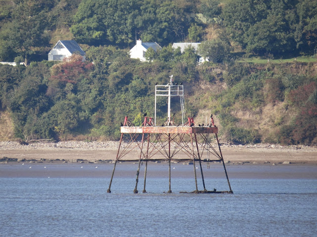
One of my favourite spots on the coast is Dunmore East, lovely thatched cottages, a lovely cliff top park, nice beach with picnic area and on a sunny day it has views to die for. We were here back in 2008 , when I got close-up and personal with the lighthouses, so contented myself this time with views looking down at the harbour. One of my favourite Irish lighthouses (I do tend to say that about a lot of them!) this one has a rather unique design - in Ireland anyway. It was built in 1825 by the great Alexander Nimmo, a Scottish engineer who built numerous harbours and bridges, though, as far as we are certain, this is his only lighthouse. There is a school of thought that he says he was also responsible for building the beacons at Tramore Bay too, ( here ) but there is some dispute over this. I am told the lighthouse resembles a fluted Doric column. I'll go along with that. Note the new pierhead light and also Hook Head across the estuary in the background

Killea Village

Image
The little hamlet of Killea lies about a mile inland from Dunmore East, on high ground overlooking the coast. An ancient topographical dictionary of the area, dated 1837, says the village contained "Round Tower (stump of) supposed to have  been an ancient lighthouse" Well, I looked but couldn't see the ruins of a round tower, either in the current church grounds, or in the graveyard, with the ruined square tower opposite it. And I can find no further clues to its existence. I suspect it was once the old church, rather than a lighthouse.

River Barrow and River Suir lights

Image
A selection of lights along the Rivers Barrow and Suir, between Ballyhack and Waterford. Once upon a time, Waterford was the destination of the mail boat from England and the Barrow and Suir weren't the easiest rivers to navigate, This one is actually described as 'the little lighthouse' in a route of a walk of the area. In Cheekpoint, go down the road next to the store. At the bottom turn left and follow the road around. It degenerates into a path and thence to the river's edge. The lighthouse is about 50m southwards Don't know if this is a beacon or a daymark. Looks like its on the westerly entrance to Kings Channel, which branches from the Suir to form Little Island, on which sits a swanky hotel and golf course. This view from the little car ferry that visits the island from Ballynakill. These are all around Cheekpoint where the Barrow and Suir merge. Took me ages to find this one. Visible from the 13th green at Faith...

Duncannon Rear Light

Image
We passed by Duncannon Rear Light on the road from Duncannon to Ballyhack and took these photos. Not much different from when were last there in 2008 , when we took our photos from the exact same spot. This is the original 1817 Roches Point Light, deemed too small for that location, and transported to Duncannon in 1838. A paper dated from the 1860s indicates that there was actually a third fixed light at Duncannon at that time, located on top of Black Hill. I can't even find Black Hill on any maps!

Duncannon Fort

Image
The last time we were in Duncannon , we approached it from the north, paid our entrance fee into the fort and got some good close-up photos of the light. This was back in 2008. We had thought that the fort represented about all there was to see. So we were very surprised approaching Duncannon from the south to find a pretty little village and a glorious sandy beach which we walked and were able to get a new perspective on the light. Apparently a light has shone from this point since the eighteenth century, helping ships up the treacherous waters of the River Barrow. The river is full of banks and shoals and bars and, by lining up the fort light with the Rear Light, about a mile further north, the right approach up the river can be made.

The First Light

Image
Here's an interesting question (or perhaps it isn't) Where was Ireland's first lighthouse?  Well, according to tradition, St. Dubhan, a Welsh monk, and contemporary of the much more famous Patrick, came to this lonely peninsula and established a monastery here in 452ad (about tea-time, as Monty Python would say) Here he established a lighted beacon for ships to warn them of the treacherous coastline hereabouts, a beacon that was tended for 700 years until the Tower was built in the early 13th Century. But where was it, this beacon? It was probably a chauffer on top of a mound of stones. Adjoining Hook Lighthouse itself is an old wall and a small plaque on a wall saying 'Site of Monks' Chapel' To my eyes the wall in the top picture looks younger than 5th century but I'm no expert. If they had the chauffer right on the point, then it would probably have been around the site of the present tower. Of course, they could have had it about a...

Hook Head Lighthouse

Image
We'd visited Hook about ten years previously, in our pre-digital camera days, but had somehow come away with very little in the way of photographic evidence. We decided to right that particular wrong this time! The last time, we did the tour, so we decided against it as we had a lot of stuff planned. If the Fastnet Light is the most iconic of the Irish lighthouses, then Hook Head is the grand-daddy of them all. The blurb reads that it is the oldest operational lighthouse in the world, though I'm not so sure about that. Okay, the original tower was built in the early 13th Century but it has been built and rebuilt many times since then and it wasn't operational for all those years either.  But it is a beauty of a lighthouse. The original tower was built by the Normans to guide ships up the River Suir to the town of Ross. The nearby monks had been installed as custodians of the light, which was a coal fire burning on the tower's top. With the dissolutio...

Passage Point, co. Waterford

Image
A few days down in Waterford and boy, were we blessed with the weather. After a rubbish August, we got endless September sunshine. Best country in the world when the sun shines! We decided to take the Passage East to Ballyhack ferry, joining Waterford to Wexford, and visit the lighthouse at Hook Head. On the way, we stopped off at Arthurstown to view this screwpile lighthouse in the middle of the Suir. I thought it was the only Leinster lighthouse I hadn't got, but seeing as it's joined to the Waterford side of the river by a sandbank, presumably it's a Munster lighthouse instead.  We might have got a bit better picture on the short hop down from Ballyhack to Arthurstown if there had been any stopping places but the pier at Arthurstown offered as good a vantage point as any. As you might have guessed this a screwpile light approximately 23 feet above the River Suir. It has a fixed light and was constructed in 1867. The other three screwpile lights in Ireland are at...

The Baily, Howth

Image
The last time I photographed the Baily was on a trip by ferry to Holyhead and the weather didn't help me to get a good view This time, my intrepid brother-in-law Aido managed to get a much better photo from the same ferry! The original light here was a brazier atop a cottage on the top of the hill (where the bungalow below the Summit car park now stands) The second light was a proper tower built on the same site but proved to be too high. Finally they got it right in 1814! This iconic light is actually difficult to photograph from the mainland, as the compound gate and the contour of the land conspire against you

Tuskar Rock

Image
Tuskar Rock lighthouses is one of the great Irish lighthouses. The oldest Rock lighthouse on our coasts that is still in active service (South Rock off the coast of county Down is older but is long derelict) Tuskar has guarded the treacherous shoals and submerged rocks off the south east coast of Ireland since 1815. The area itself is where the Atlantic Ocean sweeps up the Irish Sea and can be subject to ferocious seas, such as the one that swept away the workmen's huts when the light was under construction, killing ten of them instantly. The remaining fourteen clung grimly to the rocks for 48 hours until rescued.  But how to photograph it? Well there are distant views from the coast - probably St Helens or Carne are your best bets, though you'll need good magnification. I looked around for boat tours - as they do for the Fastmet or Rockabill, but the only company who do them appear to be Harbour Thrills , a Wexford based company. They mention the Tuskar in their intr...