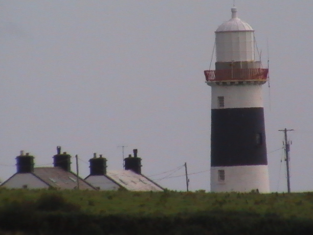
Friday, September 19, 2008

Arranmore Island

Bikes and taxis are available to hire on the pier, say the guide books. Not in September, they're not. So began the long hike from the pier to the lighthouse on the far side of the island. You go up and up and up. And up and up. And then, for the last mile, down. Its about four miles there, a lonely walk but spectacular views of the bay and at least its all on tarmac.
Although a station was established here in the eighteenth century, it was demolished when Tory Lighthouse opened. However, the current light was erected in 1865 after protests from the islanders.
On the way back, for the first time in 30 years, I hitched a lift from a passing truck!

Tory Island

On my trek across Arranmore Island (see a previous post), I could see a light blinking, far to the north, past Bloody Foreland. This is the light on Tory Island, although the island itself was not visible.
Indeed, for the first fifteen minutes of the 50 minute boat crossing from Magheroarty, the island was still not visible, though it was obvious we were heading for the light. Traveller beware! The boat crossing was one of the stormiest I have experienced, particularly the nearer you get to the island. Worse still, it cost 26 euro.
There is a tarmac track from the pier in West Town (approx 30 houses, and much bigger than the 10 houses in East Town) out to the lighthouse. In retrospect it seems amazing that I managed to miss it. The main road towards the west actually changes into a grass track which I soon found, ends in a bog. It was only by picking my way very carefully out of this, at the expense of soaked feet, that I discovered the tarmac track!
The distance, despite other sources, from the ferry to the light is about one mile, not the 2.5 miles I had been bracing myself for. Located on the western tip of the island, the lighthouse was erected in 1832.
Below, the light on West Town pier.


See also 2016 post here

The Sound of Aran

The sea route out of Burtonport, whether by the Arranmore ferry or on fishing boats, is fraught with dangerous shoals and reefs and a very definite route must be followed. Here, although not strictly lighthouses, are some of the many lights that mark the route.


Ballagh Rocks

Located in the Sound of Aran, easily viewable from the boat that regularly plies its trade between Burtonport and Leagbarrow on Aranmore Island. A comparatively new lighthouse, built in 1982. There are great views from the top of Arranmore Island of the light and the surrounding bay.

Sunday, September 14, 2008

Spit Bank, Cork Harbour

I tried locating this lighthouse from Whitegate on the eastern bank of Cork Harbour but it isn't visible. Best seen by driving through Cobh until almost at the end of the town and then driving down a cul de sac along the front.
Doesn't really look much, but the Lighthouse Directory waxes lyrical about it. It is apparently "exceptionally rare and historic" being one of only three survivors of Alexander Mitchell's "screwpile lighthouse" design. Built in 1853, it marks a mud bank in the harbour, see pale water below.


Roches Point


You'd think one of Ireland's most famous lighthouses - it is mentioned regularly on weather reports - would be signposted! Forget it. From Whitegate continue south and then take the turn right where Trabolgan has its entrance. Miss the turn and you end up in Gyleen.

Aside from the lighthouse and outbuildings, guarded by a red CIL gate, Roche's Point is home to a line of very picturesque brightly painted terraced houses all facing inland towards Cobh. "When the weather's good, the views are spectacular," a resident told me. "However, at the moment, you can't even see Cobh - its utterly ridiculous. Still, at least the foghorn isn't blaring!"

Built in 1835, this originally housed Duncannon North Light (see elsewhere), which dated from 1817. Stands as a sentinel on the eastern entrance to Cork Harbour.


Ballycotton

Comparatively easy to find, lying as it does on an island off Ballycotton harbour, from where the first two pictures are taken. Actually it is on the second island out (see below) The bottom picture was taken from the north shore of Ballycotton Bay. Built in 1851, this lighthouse is completely black, save for a red galley rail and a small white hoop just above it. I love the path scored on the island's northern face like the mark of Zorro!


Capel Island

A drive down through Ballymacoda and basically keep going until you see signs for a Dominican camp(?) The road descends sharply to Knocknadoon Head pier, which doesn't appear to serve any village. Capel Island lies just off the headland.
Built in the 1840s, this would probably have looked like Ballycotton (see entry above) had it been completed. The island is now run by Birdwatch Ireland.
A stump. That’s all there is. No more.
A nippled breast that rises
From the fathomless domains,
While loud gulls in many sizes
Skim like paper aeroplanes.
A stump. That’s all there is. From shore,
She bears her breastbone proudly,
Unabashed and unashamed,
While around her, waves crash loudly
As the sky becomes inflamed.
A stump.
That’s all there is.
No more.

Youghal

Marking the easternmost point of the county Cork shoreline, Youghal lighthouse is described as being accessible from the N25. It isn't. The N25 now skirts the town. You need to go into the town and simply follow the main road to the southern part of the town and sure enough, it is on the former main road.
Like Mine Head below, this was built by George Halpin, a year later in 1852. It commands a spectacular view (don't all lighthouses?) across the harbour to county Waterford.
See also post about the original lighthouse to stand on this spot here


No idea who is responsible for this sign. George Halpin was no relation of Robert Louis Stevenson's. In fact he was born well before Stevenson. Halpin had no hand nor part in the construction of Bell Rock lighthouse, though Robert Louis Stevenson's ancestor did!!

Mine Head


Off into the small but perfectly formed gaeltacht enclave in county Waterford to seek out Mine Head lighthouse (teachsolais?) Of course there are no signs and now the signs are in Irish! Great! Didn't actually find the road. I tried three different roads, all of which ended up in farms. This is the nearest I got!Built in 1851, it is apparently Ireland highest lighthouse, so my picture unfortunately does not do it justice.

Ballynacourty Point

A blitz of lighthouses in the west county Waterford / east county Cork area one September day with the weather gradually deteriorating. My slow progress along the coast indicative of the lack of signposting. Finding the lighthouses was more down to judging sense of direction as there is no help! This is Ballynacourty Point on the northern point of Dungarvan harbour. Found by taking the local road skirting the harbour until you can go no more, turn inland and at the T junction turn right up the road marked cul de sac. The lighthouses, along with the usual dire warnings, is located down a long skinny lane between holes 6 and 7 of the golf-course (Golfers have to cross this lane)

The lighthouse itself was built in 1858. The picture below was taken from An Rinn on the south shore of Dungarvan harbour.